
CARTAGENA
Parque Torres
30201 - CARTAGENA
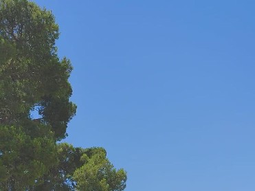
The Torres Park - popularly known as Castillo de los Patos (Castle of the Ducks) by the inhabitants of the pond that adorns its course - is situated on the hill of La Concepción, the highest in the city. This privileged place originally had a sacred function and later a defensive function from the Muslim period, when the Alcazaba was located here, passing through the medieval fortification, to a bastion from the 18th century onwards. Having lost its strategic value, it was recovered as a public space for the city as a park in 1924, designed by the architect Víctor Beltrí, as a classicist ensemble very much to the taste of the time. During the Civil War, one of the batteries to repel bombing raids and the siren that warned the population of the arrival of the enemy aircraft attack was located on the top of the hill. Since the 1960s, various works have been carried out, with botanical renovations, improvement of accesses and recovery of archaeological remains and their enhancement as a tourist resource. The top of the hill is crowned by the Castillo de la Concepción. Archaeological studies show that the keep of the fortification was part of a single construction plan dating from the end of the 13th century, which included the fortresses of Lorca, Aledo, Moratalla and Cartagena. Materials of Roman origin were reused in its construction, including a white marble slab dedicated to Lucio Emilio Recto and a replica of the same, which now stands as the lintel of the entrance door to the tower. With the evolution of defence and attack techniques, the medieval fortification lost its strategic value. After its recovery and enhancement as a tourist resource, it can be visited as an Interpretation Centre of the History of Cartagena, managed by Cartagena Puerto de Culturas. On the route through the park there is a rest area presided over by the Lantern, a 9th century Arab lighthouse that served as a guide for sailors in the port of Cartagena. Its circular truncated cone-shaped tower was crowned by a large lantern. It also served as a watchtower, forming part of the defensive system against Berber invasions. Next to the lantern, providing shade to this space is one of the most spectacular botanical elements in the park, an Australian Fig Tree (Ficus Macrophyllla), whose spectacular reticular root system is outstanding. The large stature and wide canopy of this large species make it very attractive as a shade tree for parks and gardens. Its flowers are small in size and it withstands drought and proximity to the sea well, which is why, together with its exotic appearance, it was widely used to decorate the promenades and gardens of Cartagena and other maritime cities at the beginning of the 20th century. Walking through the park it is common to be accompanied by other of its tenants, the peacocks, which usually stroll through its gardens and the viewpoint of the esplanade that occupies what used to be the old San Patricio Battery, from where you can enjoy a wide panoramic view of the city and its port.

MOLINA DE SEGURA
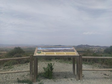
Plaza Mirador del Castillo
30500 - MOLINA DE SEGURA
"Mulina", así era como se denominaba antiguamente la zona de la muralla y la alcazaba del barrio del castillo de Molina de Segura, restos de un antiguo enclave medieval que servía para controlar y defender la vega media del Río Segura y a sus gentes. Los documentos de la época reflejan que este lugar ya existía en el siglo IX d. C., sin embargo, no se encontraron restos de la alcazaba hasta los siglos XI, XII y principios del XIII d. C. Actualmente, se puede disfrutar del espacio gracias a la reconstrucción que se ha llevado a cabo de la zona. De hecho, se puede acceder al Mirador del Castillo y a la Casa de la Maita, excavada entre los años 2006 y 2010. Varias calles del pueblo dan acceso al mirador al que se puede subir desde una plataforma donde se encuentra la alcazaba. Además, desde la zona se observa una torre rectangular y el lienzo de muralla y si se sigue caminando un poco más, se llega al silo-pozo de la nieve. Una estructura vanguardista permite a los visitantes disfrutar del espacio y contemplar toda la Vega Media del Río Segura. Sin duda, una mirada al pasado andalusí de la zona.


PUERTO LUMBRERAS
PUERTO LUMBRERAS
Situado en el Cerro del Castillo nos ofrece una vista panorámica de gran parte del municipio y de las sierras que lo rodean. Este mirador forma parte del entorno "Medina Nogalte", se trata de un conjunto patrimonial turístico, con una fortaleza medieval islámica del siglo XII y más de un centenar de casas-cueva, que conforman uno de los enclaves trogloditas más destacados del Sureste español.

YECLA
Paseo Barco de Ávila, s/n
30510 - YECLA
Vista panorámica de la ciudad

CALASPARRA
Paraje las lomas s/n
CALASPARRA
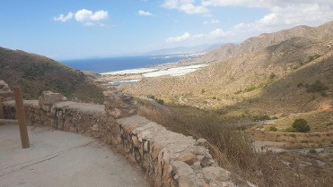
Una bonita panorámica de la vega y arrozales de Calasparra. La mejor manera de conocer la importancia que tiene la vega alta del Segura y los arrozales calasparreños la obtenemos recreándonos en este impresionante mirador

YECLA
C/ Santo Cristo, s/n
30510 - YECLA
Located in the ascent to the Castle, it offers magnificent panoramic views of the town of Yecla, on which the monumental dome of the Basílica of “La Purísima” or “Iglesia Nueva” (New Church) dating from the 18th to 19th century and the majestic tower of the “Asunción” Parish Church or Old Church (“Iglesia Vieja”), from the 16th century, stand out.

ÁGUILAS
Bahía de Levante (al final)
30880 - ÁGUILAS
The result of erosion by the sea and the wind, it resembles an eagle's beak jutting out of the sea. From its vantage point there is a beautiful panoramic view of the town.

ALBUDEITE
Calle Arriba, 26
30190 - ALBUDEITE
Controlar buena parte de la vega que riega el río Mula es posible desde este mirador, que se ubica junto al enclave que ocupó el castillo de Albudeite. Al otro lado del río Mula, se encuentra el paraje de la Huerta Cara, lugar llamado así por lo apreciadas que eran sus tierras para los vecinos de la localidad, y en el que destaca un conjunto de viviendas conocidas como La Barraca o Casas de los Ingenieros.

CAMPOS DEL RÍO
Plaza de la Iglesia
30191 - CAMPOS DEL RÍO
Tranquilidad. Eso es lo que se respira en el Mirador del Castillo. La plaza da hacia la huerta y los Bad-Lands, donde se puede disfrutar de un momento de paz. A la espalda se encuentra la fachada de la Iglesia San Juan Bautista, al frente la Vega del Río Mula.

CIEZA
Collado de la Atalaya
CIEZA
Situado en el collado de la Atalaya donde se alza la ermita de la Virgen del Buen Suceso, patrona de Cieza. Su magnifica ubicación, rodeado de una frondosa pinada, ofrece al visitante la oportunidad de contemplar la huerta y el meandro que el río Segura dibuja en el casco antiguo de la ciudad. Un estupendo mirador para hacer fotografías panorámicas de Cieza.

CIEZA
Subida a la Ermita
CIEZA
Es un lugar emblemático, ya que en este mirador se encuentra la ermita que alberga la imagen del Santísimo Cristo del Consuelo a la que los ciezanos tienen gran devoción. Ofrece una bella panorámica del casco urbano, la huerta y la Atalaya.

PUERTO DE MAZARRÓN (MAZARRÓN)
Calle de la Reya, 3
30860 - PUERTO DE MAZARRÓN (MAZARRÓN)

BOLNUEVO (MAZARRÓN)
Avenida Pedro López Meca, 174
30877 - BOLNUEVO (MAZARRÓN)

LA MANGA CARTAGENA (LA MANGA DEL MAR MENOR)
Urb. Monteblanco
LA MANGA CARTAGENA (LA MANGA DEL MAR MENOR)
Shaded viewpoint from where you can see a general panoramic view of La Manga del Mar Menor and its surroundings.

LA MANGA CARTAGENA (LA MANGA DEL MAR MENOR)
Subida a Monte Blanco Km. 3
LA MANGA CARTAGENA (LA MANGA DEL MAR MENOR)
Located at the top of the Monte Blanco urbanization, from this spectacular vantage point you can enjoy privileged views of La Manga del Mar Menor

ABANILLA
ABANILLA
Situado en Barninas, pedanía de Abanilla que mantiene otro monumento al sagrado corazón de Jesús y donde se pueden tener unas espectaculares vistas de unas de las pedanías más pobladas de Abanilla con alrededor de unos 800 habitantes. Se sitúa a unos doce Km de Abanilla casco urbano, es de visita obligada su bonita iglesia parroquial de Ntra. Sra. del Rosario.

ABANILLA
ABANILLA
Situado en Macisvenda, pedanía situada junto a Barinas y en la que también se levantó otro monumento bajo la advocación al Sagrado Corazón de Jesús, al estar este en el punto más alto de la pedanía hace que sus vistas sean privilegiadas viendo todas las sierras que rodean el municipio de Abanilla y ejercen ese efecto pantalla que le protegen de las borrascas y el frío al municipio de Abanilla.
ABANILLA
ABANILLA
A Mitad de la Ctra. de Abanilla- Pinoso, RM-412 en un montículo se erigió una ermita del siglo XVI en honor a Santa Ana, sobre los restos de una antigua atalaya de vigilancia árabe, esta permitía dar aviso al castillo árabe del Lugar Alto en el caso de que vinieran tropas enemigas.

ABANILLA
ABANILLA
Donde se sitúa el monumento al Sagrado Corazón de JesúS, en el casco urbano de Abanilla, la imagen fue erigida en 1946. Obra de los escayolistas murcianos, Nicolás y Anastasio Martínez (autores de la imagen monumental del Corazón de Jesús de Monteagudo). Está enclavado a poniente de la meseta del cerro, en el conocido Lugar Alto (por tratarse del lugar con mayor altitud de la localidad). En 1957 se hicieron las escaleras de acceso desde la plaza del Ayuntamiento, más de 180 escalones. En este lugar se asentó el castillo árabe, las vistas privilegiadas, permitían a los centinelas vigilar la entrada enemiga desde las zonas colindantes.