

LOS BAŃOS (ABANILLA)
Carretera de las Bańos de Fortuna
LOS BAŃOS (ABANILLA)
El cauce del Río Chícamo está catalogado como Lugar de Importancia Comunitaria (LIC). Se trata de un tramo fluvial de caudal permanente con sistemas de ramblas y humedales asociados. Entre su flora se pueden apreciar palmeras, los baladres, los juncos y los cañaverales y el protegido taray. De la fauna asociada al entorno destaca el fartet (Aphanius Iberus) y el invertebrado Coenagrion mercurial. Además se puede encontrar la cigüeñela (Himantopus himantopus) y pequeños moluscos con caparazón en forma de caracola, siendo alguno de ellos endémicos de este lugar. CÓMO LLEGAR Para la visita al nacimiento será necesario tomar la carretera comarcal A-9, debiendo pasar por las pedanías de El Partidor, El Tollé y La Umbria. Dejando atrás el cruce de Macisvenda (dirección a El Cantón) nos dirigiremos hacia el caserío del Chícamo, donde se hará la última parada. Una vez allí dejaremos el medio de transporte utilizado y descenderemos por un camino de tierra que conduce hasta al nacimiento. ** Accediendo por La Umbria también se puede ver uno de los tramos más bonitos, el cañón de El Cajer.

MACISVENDA (ABANILLA)
El Partidor, La Umbría, Macisvenda.
30648 - MACISVENDA (ABANILLA)
El cauce del Río Chícamo está catalogado como Lugar de Importancia Comunitaria (LIC). Se trata de un tramo fluvial de caudal permanente con sistemas de ramblas y humedales asociados. Entre su flora se pueden apreciar palmeras, los baladres, los juncos y los cañaverales y el protegido taray. De la fauna asociada al entorno destaca el fartet (Aphanius Iberus) y el invertebrado Coenagrion mercurial. Además se puede encontrar la cigüeñela (Himantopus himantopus) y pequeños moluscos con caparazón en forma de caracola, siendo alguno de ellos endémicos de este lugar. CÓMO LLEGAR Para la visita al nacimiento será necesario tomar la carretera comarcal A-9, debiendo pasar por las pedanías de El Partidor, El Tollé y La Umbria. Dejando atrás el cruce de Macisvenda (dirección a El Cantón) nos dirigiremos hacia el caserío del Chícamo, donde se hará la última parada. Una vez allí dejaremos el medio de transporte utilizado y descenderemos por un camino de tierra que conduce hasta al nacimiento. ** Accediendo por La Umbria también se puede ver uno de los tramos más bonitos, el cañón de El Cajer.

ÁGUILAS
Playa del Hornillo
30880 - ÁGUILAS
Beautiful corner formed by a wide mosaic staircase located in front of the Hornillo beach. Handcrafted by its creator Juan Martínez ‘Casuco’.

CALASPARRA
Paraje de la Cueva del Puerto
30420 - CALASPARRA
It has a 700-meter-long route illuminated and acoustically set, where you can observe different rooms and galleries formed by various speleothems, spectacular formations of stalactites and stalagmites of great diversity of colors, etc. The Gaudí Room, one of the most exemplary rooms where we can observe eccentricities of incomparable beauty in its basement. The Cueva del Puerto, a tour of approximately one hour and ten minutes, in which the visitor, in addition to the tourist visit, will visit the Luminous Minerals Room, unique inside a cavity in Europe, with a representation of about 1500 minerals from around the world. A unique resource of the Region of Murcia in Hydrothermal Caves.

CEHEGÍN
Plaza del Castillo s/n
30430 - CEHEGÍN
Did you know that these arcades date back to 1725? They were once built to house the boxes that some families owned. The fact is that wealthy people used to go to these boxes to comfortably watch the shows that took place in the square. The square is famous for having hosted numerous activities and shows such as bullfights, religious ceremonies and street markets. The change in the building took place in the 19th century, when it was covered with walls, converting the columned space into rooms or rooms for the sale of meat and fish, later called butcher's shops.

LAS LOMAS DEL RAME (LOS ALCÁZARES)
Las Lomas del Rame
30710 - LAS LOMAS DEL RAME (LOS ALCÁZARES)

SANTIAGO DE LA RIBERA (SAN JAVIER)
C/ Maestre
SANTIAGO DE LA RIBERA (SAN JAVIER)
Training Center and home to the renowned Patrulla Águila (Eagle Patrol). Except for occasional events, the academy is not open to visitors, but you can still admire the entrance and the long central avenue leading to the facilities.

LA MANGA SAN JAVIER (LA MANGA DEL MAR MENOR)
Km. 13
30380 - LA MANGA SAN JAVIER (LA MANGA DEL MAR MENOR)
VER VIDEO (Realidad Virtual) El primitivo faro se construyó en 1862 sobre una torre vigía del siglo XVI, que junto con otras 29, defendían las costas murcianas de los ataques corsarios. Hasta que se automatizó el faro en 1929, el servicio del faro era llevado a cabo por dos fareros. El actual faro se inauguró en 1971, tras ser demolido y construido de nuevo para adaptarse a la nueva normativa. Se trata de una torre cilíndrica de hormigón armado de 29,20 m de altura. . La parte superior está rematada con dos cámaras de servicio e iluminación sobre dos plataformas con barandilla de acero inoxidable. El sistema de iluminación está equipado con una linterna que emite cuatro destellos de luz blanca cada 20 segundos con señal de 4º orden y alcance de 22 millas.

DOLORES (TORRE PACHECO)
Cabezo Gordo, ladera sur
30739 - DOLORES (TORRE PACHECO)
La Sima de las Palomas is located on the southern slope of Cabezo Gordo, the only mountainous elevation in the municipality of Torre Pacheco, and a historical reference for navigators and residents of the Campo de Cartagena. In 1991, the accidental discovery of the jawbone of a Neanderthal prompted the scientific excavation of la Sima de las Palomas, the most important archaeological site of Neanderthal man in the Spanish Mediterranean. The excavation work has made it possible to recover more than 300 skeletal fragments, between bones and teeth, which highlight the low height of the adults despite their great robustness typical of Neanderthal muscles. They have been dated at 50,000 years, i.e. during the last ice age. The three almost complete skeletons, excavated in an anatomical connection and in a good state of preservation, are of exceptional importance for the study of the Neanderthal fossil record. The young woman "Paloma" and the child were found under an accumulation of large stones, with knees and elbows bent and hands next to the face, suggesting that they could have been buried intentionally. The information that these remains offer us is fundamental to understand the long evolutionary chain of the human being. The Neanderthals of la Sima de las Palomas left abundant remains of the animals they used to hunt, from horses, deer, aurochs and the Spanish goat to turtles and rabbits. Research into the phytoliths on their teeth indicates that they also ate vegetable matter. In order to obtain and prepare food, they carved tools from flint, limestone, marble, calcite, quartz and quartzite, which have been found at the site, typical of Mussolithic technology in the Middle Palaeolithic period. This hill of aggregates and quartz is also of great biotic, landscape and cultural interest. Declared a Protected Landscape in 1998, it has a typical fauna and an almost exclusive flora.
CALASPARRA
Carretera Santuario
30420 - CALASPARRA
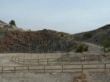
El cAÇbezo Negro de Calasparra es un afloramiento de rodcas laproíticas siendo una de las más representativas chimeneas vol´canicas de tipo lipolito, descubierto por la erosión

CEHEGÍN
Carretera de Cańada de Canara RM, B20
30430 - CEHEGÍN
Although in ruins, due to its destruction by the French army during the War of Independence, the chapel has become a very attractive tourist attraction. It was built in the 15th century and is situated in a strategic location, being a crossroads between the town, the river, the district of Canara and the border town of Calasparra.

")
MORERAS / BOLNUEVO (MAZARRÓN)
Puntabela
30877 - MORERAS / BOLNUEVO (MAZARRÓN)
The 35 km of coastline offers a variety of over 30 beaches and are one of the principal natural attractions of this area due to its special characteristics. Outstanding beaches are La Isla, Bahía, Nares, El Castellar and Bolnuevo. The coast of Mazarrón has a great number of unspoilt coves located in the foothills of the Sierra de las Moreras with a natural beauty that focuses not only on the physical environment that surrounds them, but also based on the depth of the sea. The clear blue sea has all kind of sub aquatic fauna and flora, and it is also possible to see and visit submarine caves. Coves that stand out are Cala Amarilla, La Grúa, Parazuelos, Covaticas, Percheles, etc., some forming part of other districts of Mazarrón.

CAMPOTEJAR ALTA (MOLINA DE SEGURA)
Campotéjar
30627 - CAMPOTEJAR ALTA (MOLINA DE SEGURA)
El humedal de las Lagunas de Campotejar lo constituyen cinco antiguas lagunas que formaban parte de la depuradora por lagunaje de aguas residuales de Molina, con una superficie total de 225.415 m2. Las aguas depuradas que circulan por las lagunas proceden de la actual Estación Depuradoras de Aguas Residuales enclavada en el lugar que ocupaban las lagunas anaerobias. A lo largo de estos años este espacio ha seguido un proceso de naturalización que lo ha convertido en un lugar de importancia internacional En mayo de 2006 la Bióloga municipal elabora un "Proyecto de restauración ambiental y gestión municipal del humedal de las Lagunas de Campotejar en Molina de Segura", en el que se justifica la importancia de este humedal por ser el segundo continental más importante de la Región de Murcia en cuanto a concentración de aves acuáticas, y el cuarto en importancia en el conjunto de todos los humedales de la Región; con la presencia de aves incluidas en los catálogos regionales, estatales e internacionales, clasificadas como vulnerables y dos de ellas en peligro de extinción (Malvasia cabeciblanca y Cerceta pardilla). Las lagunas de Campotejar aportan al área de influencia del conjunto del humedal de Salar Gordo un valor añadido, ya que atraen a un gran número de especies de aves acuáticas de gran interés mundial y regional, muchas de ellas reproductoras. La vegetación está influida por cuatro factores fundamentales: 1. Los ciclos de inundación-desecación a los que pudieran verse sometidas las lagunas; 2. La elevada salinidad del suelo, 3. El clima dominante en la zona 4. La composición del agua vertida. En el entorno del humedal de las Lagunas de Campotejar nos encontramos con grandes parcelas de cultivos de regadío localizadas al este, con una topografía suave de la que resaltan levemente algún que otro pequeño cerro en la zona oeste. De los elementos antrópicos es la instalación de la EDAR Campotejar la que aparece más visible a los ojos del visitante. Cuando nos acercamos a las lagunas, el elemento que destaca y levanta la vista es la gran extensión de láminas de agua, en cuya superficie se reflejan los elementos que rodean las lagunas. La importancia del humedal de las Lagunas de Campotejar radica en que puede llegar a albergar numerosas especies de animales amenazados, constituyendo un elemento diversificador en el conjunto de los ecosistemas terrestres. Es un lugar clave dentro de las rutas migratorias de las aves acuáticas, lo que convierte las Lagunas de Campotejar en uno de los más importantes humedales de la Región de Murcia, en cuanto a la concentración durante el invierno y en pasos migratorios de aves acuáticas, lo que le ha valido el reconocimiento internacional de ser declarado "sitio Ramsar"


CABEZO DE LA JARA (PUERTO LUMBRERAS)
PARAJE NATURAL CABEZO DE LA JARA.
3890 - CABEZO DE LA JARA (PUERTO LUMBRERAS)
Sendero Interpretativo sobre la flora existente en el paraje asi como sobre los sistemas de captación de agua para diferentes usos. El sendero tiene 1.800 metros. Se inicia en la puerta del Albergue juvenil y es circular.

SANTIAGO DE LA RIBERA (SAN JAVIER)
Paseo Colón
30720 - SANTIAGO DE LA RIBERA (SAN JAVIER)
Perhaps the most beautiful seaside promenade along the Mar Menor coast, spanning two kilometres, flanked by century-old palm trees, and mostly pedestrian. Along this promenade, apart form enjoying, the beach and sea on one side, you can admire various summer houses from the late 19th and early 20th centuries: Chalet Barnuevo, Casa Conde Lisea, Villa San Franciso Javier, Torre Javiera, Villa la Pinada… Amidst these historc buildings, there are no more than half a dozen apartment towers, giving Santiago de la Ribera a unique skyline. The Yacht Club stands out as a prominent visual landmark on the promenade, with its side elevations resembling the shape of a sailboat. It’s quite common to witness the club’s activities, including regattas and a lively maritime sports atmosphere or competitive events featuring numerous international athletes. Throughout the promenade, there are numerous open terraces and kiosks, operating almost year-round, offering the opportunity to enjoy a meal, dinner, ice cream, or simply a refreshment in a highly pleasant seaside ambiance. However, the unique feature in Santiago de la Ribera is the Tiflológico Aeronautical Museum, a new outdoor space accessible. The current exhibits in the MAT (Aerospace Tiflológico Museum) include a three-dimensional photocall, scale models of the most iconic airplanes throughout the history of the airbase, and benches designed to capture the essence of each aircraft, reproducing their distinctive colors and aircraft insignia. The exhibits consist of: 1. Dornier J”Wal” 2. Beechcraft T-34 “Mentor” 3. North American T-6 “Texan” 4. Hispano Ha-200 “Saeta” 5. CASA C-101 “Mirlo” 6. Patrulla Águila Flight Helmet 7. Aircraft T-12 Casa-212 “Aviocar” 1974-2003 Navigation School 8. Aircraft ENAER T-35 C “Pillan” 1996-2025 Elementary Flight Trainer 9. Aircraft E-3-B Bucker 1945-1976 Elementary Flight Trainer 10. Aircraft Beechcraft F-33 “Bonanza” 1974-1994 Navigation Flight Trainer 11. Autogiro C-4 1922-1923 Experimental Autogiro built by Juan de la Cierva 12. Aircraft Casa C-352-L Junkers 52 1947-1973 Navigation School 13. Aircraft Polikarpov I-16 “Mosca” or “Rata” High-Speed Flight School 14. Aircraft Pilatus PC-21 Elementary and Basic Flight Trainer. In May 2024 we started a municipally run air festival (FASJ) which takes place on our beaches and can be enjoyed along the promenade of Santiago de la Ribera. PLAYA DE LA HITA. Between Santiago de la Ribera and Los Alcázares, you will find Playa de La Hita (La Hita Beach), abandoned old salt flats which stand out for their coastal reedbeds. Rich vegetation covers its coasline and is home to little wetlands where the everlasting flower stands out. If you have a pair of binaculars with you, you will be able to observe the small stork or the small tern, amongst other birds. This beach is listed as ZEPA (Specially Protected Area for Birds) by the European Union since it is one of the redoubts where we can find the original fauna and flora in the Mar Menor.

SAN PEDRO DEL PINATAR
Las charcas de Las Salinas, junto Molino de Quintín
30740 - SAN PEDRO DEL PINATAR
Zona de lodoterapia al aire libre. Los lodos de Las Charcas de las Salinas, son fruto de siglos de acción del sol y de las aguas de elevada salinidad del Mar Menor. El resultado es un lodo arcilloso que aplicado sobre la piel tiene un gran valor terapéutico en todo tipo de afecciones: reumatismo, artritis... El complemento ideal es un baño en las mineralizadas aguas del Mar Menor. Existen centros de Talasoterapia y Spa donde seguir tratamientos especializados. Más información https://www.murciaturistica.es/es/lodos_mar_menor/

TORRE PACHECO
Avda. de Roldán s/n
30700 - TORRE PACHECO
El Pasico area is an ideal place to spend a day with family or friends. This enclave located in the municipality of Torre Pacheco offers a pleasant space next to emblematic monuments of our land, such as the windmill (declared of cultural interest) and The Hermitage of El Pasico that has a natural icon of the Virgin Mary. Its curious story about the discovery of the image and the miraculous healing of a man are the beginning of the devotion. Throughout the year, traditional festivals and events are held here, such as the Fiesta de los Molinos (Festivity of the Mills) (last weekend in April), the Fiesta de El Pasico (Easter Monday), and the Romería de San Miguel (last Sunday in September).

ABANILLA
Carretera de Pinoso s/n (dirección Mahoya)
ABANILLA
Cada 26 de julio es costumbre celebrar el día de los abuelos: Santa Ana y San Joaquín en la abanillera Ermita de Santa Ana (situada en la carretera de Abanilla a Pinoso), cuando baja el sol y da paso a la noche veraniega, las imágenes de los padres de la Virgen María son sacadas en procesión por este paraje y acompañadas por buena parte de la población asistente. El emblemático lugar donde se emplaza la Ermita se llama "Santa Ana", aquí existió un sistema de defensa romano y posteriormente un castillo árabe cuya principal función era la de vigía. Por el ambiente musulmán que envolvió este altozano, cada mes de octubre se celebra una comida de convivencia entre las asociaciones festeras de moros y cristianos y una representación de la toma del castillo. Es evidente actualmente, una parte de la muralla de tapial que protegía este lugar de vigilancia. En las proximidades de la ermita existe un aljibe muy bien conservado cuyo origen podría remontarse a época medieval islámica, aunque posteriormente sufriera importantes remodelaciones. Se trata de una estructura formada por tres bóvedas paralelas que determinan tres aljibes independientes rectangulares, comunicados por puertas laterales.

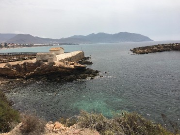
LA AZOHIA (CARTAGENA)
LA AZOHIA
30868 - LA AZOHIA (CARTAGENA)
Situada a 22Kms de Cartagena, en una cota de 70m desde la que se domina la ensenada de la Azohía. Esta construcción es de planta hexagonal y con dos cuerpos comunicados por una ceñida escalera de caracol. A la estancia mas baja se pasa por una puerta de acceso orientada a Levante, elevada sobre el nivel del suelo unos 4,50 metros, como es característico en este tipo de edificación. Su construcción se remonta, al menos, a los años finales del siglo XVI, bajo el reinado de Felipe II, con la finalidad de dar resguardo a los pescadores de La Azohía y servir de atalaya que sirviera para prevenir de la presencia de piratas en sus costas. Se accede a ella, partiendo de La Azohía por una pista militar de piedras, de fácil acceso peatonal. En la primera mitad del siglo XIX, queda desafectada para la defensa de costas, y fue entregada al Cuerpo de Carabineros. Actualmente es propiedad del Patrimonio del Estado. Está considerada como Bien de Interés Cultural (BIC).
ISLA PLANA (CARTAGENA)
30868 - ISLA PLANA (CARTAGENA)
Tradition says that it was a sow that suffered from rheumatism and that was having a lot of difficulty walking, she used to go with great effort to a certain place on the shore of the Playa de los Barcos, where she wallowed in the hot waters that flowed there. After some time, the animal was completely cured. This is the origin of these baths, at least this is the popular justification for their being called Baños de la Marrana. These baths were opened to the public on May 2, 1901, by Dr. Vera. The baths consist of two construction phases: an earlier one, dating from the end of the 19th century and the beginning of the 20th century, and a second, more modern one, carried out as a result of a series of reforms after the Civil War, in which bathtubs and internal partitions were built. The Isla Plana thermal baths were abandoned in the mid-20th century.

CEHEGÍN
La Cuesta del Partidor
30430 - CEHEGÍN
Located in the old gateway of San José de la Villa, it gave access to the interior by stone steps. The name of the Partidor comes from the fact that it was located next to the partidor of the water of the irrigation channel of the countryside where there was a public fountain with several spouts for the supply of the population. Halfway up the slope, it is worth noting a singular building with a sundial from the second half of the 9th century, which can still be seen quite clearly.

MAZARRÓN
Sierra Minera (ladera norte de Mazarrón)
30870 - MAZARRÓN
Proof of the rich Phoenician trade is that historians of the antiquity, as 'Diodorus Siculus, did chronicles like this: "... The Phoenician merchants who sailed to Iberia ... when his boat was overloaded with silver ... removed the lead from their anchors and, instead of lead, they did the stock of silver ". Phoenicians, Greeks and Carthaginians passed along our coasts until the Second Punic War brings the fall of 'Carthago Nova' (209 B.C.) and the Roman conquest. The Romans are those who undertake the greatest exploitation of the antiquity. Within the grounds of "Coto San Cristóbal” (“coto” means property) and "Los Perules" is "Corta Romana", popularly known as “El charco de la aguja” (Needle’s puddle). It’s a quarry which was originally a large front of mining works (extracting profit of the mines doing the required labours or excavations, fortify the area, arranging traffic in the enclosure and extracting usable ores), over 300m long, with an average height of more than 25m. Elsewhere in the town, as “Coto Fortuna” in Leiva, are conserved important works of Roman engineering like a draining gallery about 2km, one of the works of these most important characteristics of the Empire (not visitable nor visible because the gallery is located at 8 metres underground). The Roman company that exploited it, was named 'Societas Montis Argentaris Ilvcro', and ingots with this Roman company brand have appeared even into the Tiber, near the same Rome. The life of these miners must not have been easy, according of the finding of a human limb chained with shackles to a gallery. Mining developed during the Visigoth and Muslim period, although few testimonies were left. A large decline is perceived pointed to almost disappear. Mining industry rebirth with the Reconquista and the Christian settlements, and with it the “embryo” of what will be the current municipality of Mazarrón. Dependent on the Council of Lorca, it appeared the workers house called “Casas de los Alumbres de Almazarrón” (Houses of the Alum of Almazarrón). 1462, Henry IV of Castile granted the privilege of the exploitation of the mines to the marquisates of Villena and Vélez, keeping its splendour about 1592. Alum was used mainly as mordant to fix the dyes, exporting for the production of tapestries in the Netherlands. Also as an astringent and disinfectant intervened in leather tanning, lighting of codex and in glass manufacture. This mining wealth causes the segregation of the town and formalized in 1572 with the privilege letter signed by Philip II. In the 19th century, Mazarrón reached unprecedented and unexpected technological, economic and population levels. Free prospecting on public lands through a simple notification to the Administration, causes an authentic mining fever. Mazarrón grows rapidly and international mining companies decide to invest and modernize works. In 1886 a railway linked Mazarrón's mines with the foundry of Santa Elisa in Puerto de Mazarrón and, 1893, the mines already enjoy electricity. Thanks to its mines, Mazarrón leads the mining sector of Murcia and is situated at the national forefront. It came to undertake works up to 600m deep. At the entry of 20th century they started to feel the first symptoms of decline. Some reasons for this decline are: a) Flood of wells and incapacity for water evacuation. b) Drop in the prices of lead. c) Depletion of richest veins. d) Civil War. At the closing of the mines, Mazarrón suffers a significant emigration. Mazarrón has managed to adapt to the times recovering the ancient splendour with activities of other sectors such as tourism, the service sector,construction sector and tomatoes’ cultivation.


